
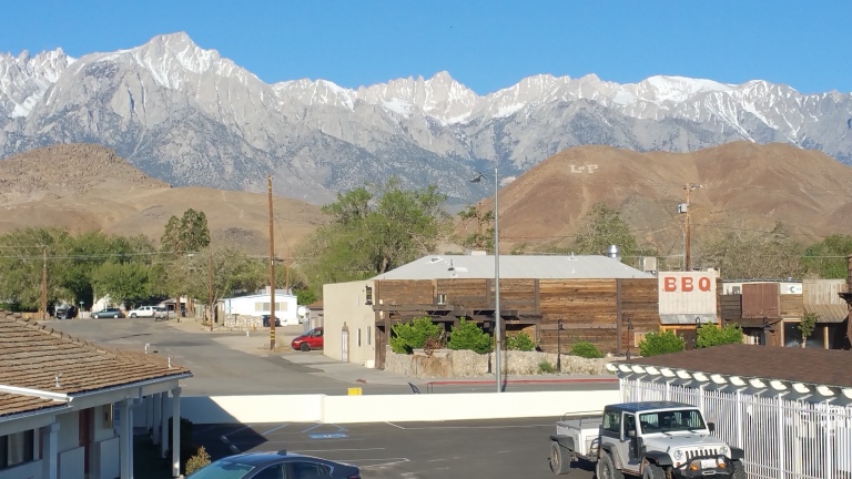
In the morning it was dark and quiet in that motel room, with the black out curtains and the hum of the a/c unit as white noise. It would have been so easy to sleep in, shut off the alarm, and let the day go by. Nope, no way though. We are going to hike across Death Valley and end up all the way right back here, possibly even in this exact-same-hotel-room in 9 days. Hell yeah, let’s do it. I popped out of bed and opened the curtains to allow the morning light flood in. “Oh my God, I see Mount Whitney!” I went over to the door and opened that right up and let the crisp morning air flood into the room. I walked out onto the balcony, stretched my arms out and greeted the beautiful Sierra Nevada with a big smile. Oh yeah, this is going to be amazing!
We quickly gathered our belongings and did the final shoving of items into the full packs. Soon we were in the hotel lobby checking out. We asked the hotel clerk if there was a place to park my car while we did our hike, and they were kind enough to let us leave it in the overflow lot. Cool, that works great! We grabbed a quick coffee and bagel breakfast sandwich from Lone Star Bistro and headed down 395 on our way to Cerro Gordo Ghost Town for our final water cache.
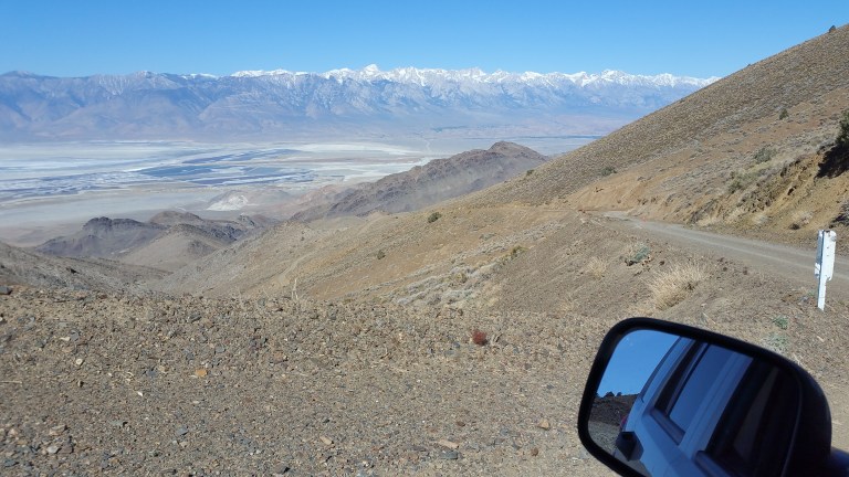
The road to Cerro Gordo is definitely for 4WD high clearance vehicles, and I was surely thankful that I have just that. It starts out as a normal dirt road for a few miles and then begins to climb. In some places, the grade is quite steep, and the sand/gravel was getting loose, so my transmission was not handling it well. I ended up putting it into 4WD Low gear to get up a couple of sections, and that worked just fine. The elevation gain is just over 4,000 ft and I’d say that overall it was a do-able drive with the right car. And by the way, the views from up there looking out to the Sierra’s are stunning. I thought excitedly about the views we would be getting from on the trail, there’s nothing like the pre-hike anticipation!
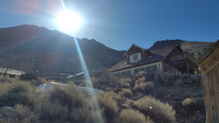
When we got there the sun was shining intensely, the way it does at higher elevations. We were now at 8,000+ ft and the wind was downright chilly. We got out of the car and nosed around a little, not fining any humans at first. It wasn’t long though, before we were pleasantly greeted by caretaker Robert who emerged from a teetering and rickety shack of a house with lots of country-ghost-town charm. He greeted us with a hardy hand-shake and let us know it was 30 F with 20 mph winds that morning. Ok, so I wasn’t making this up, it was legitimately colder up here. I started to wonder if I packed enough warm things to wear? Suddenly my fear of the cold overshadowed my fear of the heat, especially since we were planning on camping up high tonight if we made it that far.
Robert started chatting with us and as we told him what we were planning to do, he was nice enough to let us keep our 4 Gallons of water inside the main building. He gave us a little tour and told us lots of interesting stories about the place (check out the Cerro Gordo Mines’ website here). He was the best! He loves that place (had been there care taking for 20+ years!) and you can tell he puts his heart and soul into what he does. He genuinely enjoys educating visitors about the history. We could have stayed all day listening to his great stories but we still had to drive back to LP and then hitch all the way to Badwater just to start our hike, and who knew how long that all might take?
We parted ways with Robert and headed back down the steep dirt road in 1st gear, but my breaks were still stinking up a storm, smelling like hot urine. Nevertheless, totally worth being able to leave water there, as without it, the water carry would have amounted to over 50 miles! Thank you Cerro Gordo, Robert and thank you Jeep 4WD!
When we finally walked away from my parked vehicle, it was just after 11:00 am. This is it, we are finally on our way! We crossed the already hot pavement on Highway 395 and started walking South to a spot that we deemed good to hitch. We waited maybe 20 minutes with no luck, and then decided perhaps it would be easier to hitch from the Visitor’s Center about a mile and a half away, since it is on the same corner where folks would be turning off to drive to Death Valley. So we started walking and would turn and stick out our thumbs whenever we heard traffic approaching. Funny thing was, we got waved at so many times, people smiled, honked, but nobody was stopping. Several people signaled apologetically that they were only going a short distance, with a shrug. No worries, this is all part of the adventure. We’d hitched plenty on the PCT so we weren’t worried at all. Things usually have a way of working out.
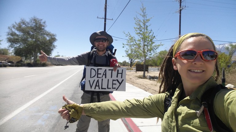
And they did. Hitch #1 turned up just after we started to walk, about 1 mile from the Visitor’s Center. A super nice, retired couple from Portland, in a Sprinter Van, stopped and asked where we were headed. We gave them a quick synopsis and they were so impressed, but they said they were actually headed to the coast. There was an awkward hesitation as we weren’t sure then what to do. Then they offered to take us down to the Visitor’s Center, and we gladly accepted the lift. As things tend to go with hitches and trail angels, we got to talking with them in those few short minutes and by the time we made it the 1 mile to the Visitor’s Center, they had agreed with each other to alter their plans and instead of going to the coast that day, they would go into Death Valley first. Seriously! They ended up driving us over 50 miles, all the way to Panamint Springs! Since there is a small resort there with a cafe, they said they would go there and have lunch, and that’s where we got dropped off. What generosity!
From there, we quickly ducked into the bar and asked the bartender to re-fill our already empty water bottles. I started to wonder…if I would have enough water, and what about Hurlgoat, would he? His body requires way more water than mine. I guess we’re out here to find that out. It was cool in that bar the way a stucco home is cool, an Earth dwelling that naturally keeps the air at a comfortable temperature even at boiling temps outside. We walked back out into the blistering heat, which was like a slap in the face as we exited through the heavy wooden door. We said goodbye to our new friends, and we were soon walking down hot black asphalt, heading…. where? Thumbs out again whenever a vehicle went by, trouble was that every single vehicle was stopping at Panamint Springs. It was like the only single place that had anything for a hundred miles, so I couldn’t blame them for stopping there. So we just walked.
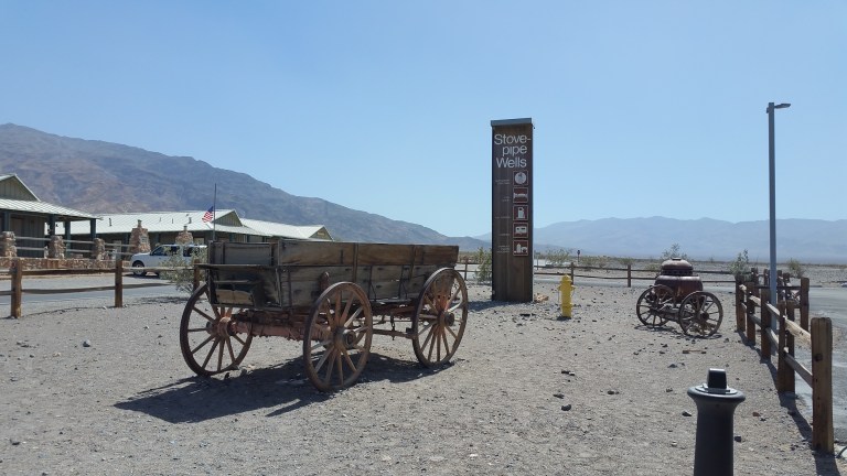
Lo and behold, there was another ride. We got hitch #2 from a man in his early 40’s perhaps, from Spain, with two young children in the back of his really nice rental car. He said the kids were half Spanish-half Brazilian, and they were there on a 3 week family vacation in California. I sat in back with the kids, since I am a child’s size anyway, and Hurlgoat sat in the front seat chatting it up with the Spaniard. I was totally okay with sitting in the back with the kids, I didn’t mind spacing out a little, watching them play their mine craft video game on their tablet and then I would get sick of looking at it and stare out the window, occasionally chiming in on the conversation. The frequent giggles from the kids was soothing, the A/C was blasting, and the gentle hum of the engine was all enough to put me out. But I held on, I stayed awake for the 30-40 minute drive. They drove us to a place called Stovepipe Wells, which was the next “place” that had anything. They had a small store, a Ranger Station (which we had stopped at the day before), and some basic, rustic accommodations. I went into the store to inquire about a restroom and the A/C in there was to die for. I could definitely see how working in a place like that all Summer would not be bad at all. The restroom was, of course, outside, and so was the drinking fountain, which we filled up more water into our bottles, again.
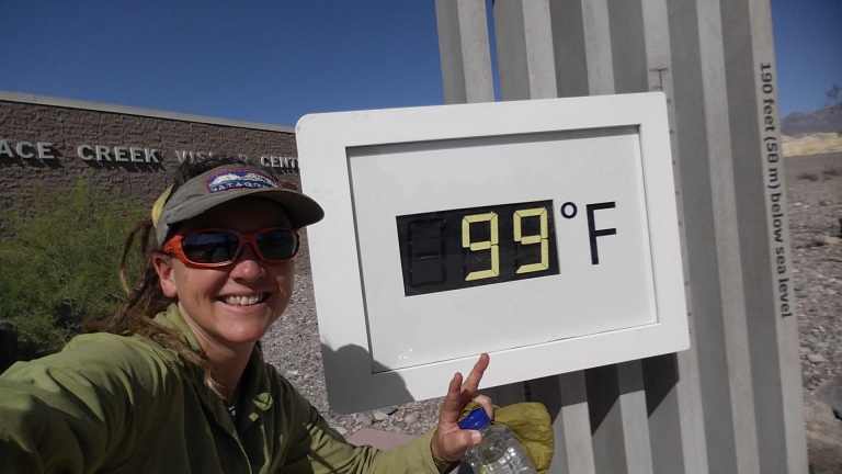
We hit the road for the third time that day, and started walking on the boiling hot tarmac. It was definitely now in the triple digits. How do those Ultra Runners do it in July? I wondered as we walked. It blows my mind. We kept walking and kept up our strategy of thumbing it when the cars came by. It was no more than 15 minutes when we got our third and final hitch with a couple visiting from Austria. They looked to be in their early 30’s and were very sweet, and spoke amazing English with an accent that pleased my ears. It turns out they were planning on going out to Badwater as well, so it worked just fine to take us along. We were so stoked this was all going so well, we were making it closer and closer to the beginning of the route, to the lowest point in the Western Hemisphere. Along the way, they asked if we minded stopping at the Visitor’s Center, which we were of course totally fine with. We got out and snagged another photo at the thermometer. It was 10 degrees hotter than yesterday, and the temperature reading fluctuated between 98-100 F as we stood there sweating.
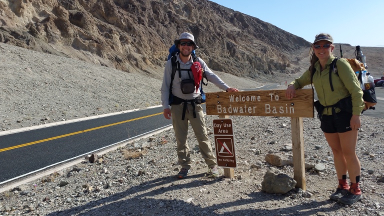
When we finally pulled up to the parking lot at Badwater, it was 4:34 pm and that very place I’d seen on computer screens and on Google Earth had made it’s way into three dimensions. I was there in real person, with all my senses, fully alive. I am doing this, I am going to walk to the top of Mount Whitney from here. Holy shit. Finally, we were finally starting out on this great adventure! The breeze picked up a bit and I noted how it felt even warmer here than at the Visitor’s Center, and was glad that it was only going to get cooler as the day wore on. I switched my InReach tracking on at 4:47 pm, after saying goodbye and thank you to the Austrians. We walked through throngs of tourists and day-hikers, and as is typical with most trail heads, within about a mile it was only us, walking out into the abyss of salt, sand and crusted mud.
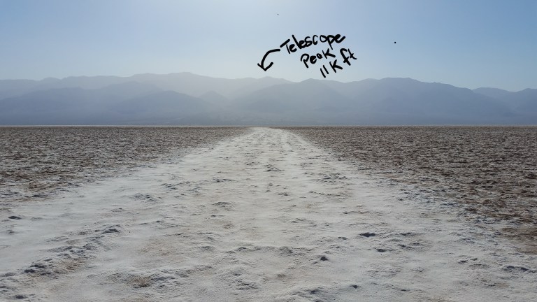
Looking straight across the basin to the Mountain range on the other side, I spotted the highest point, which I took to be Telescope Peak. We were headed straight towards the 11,000 ft mountain. Our first water cache was at route mile 6.4, at the West side of Hanaupah Canyon Road. By the looks of it, it could never have been 6 miles to the other side of the flat land, it just didn’t look that far. I don’t think I’ve ever walked for such a long distance on such a flat terrain that I could see so far. The distance was deceptive, and all I could do to check my progress was turn around and see how far we’d come.
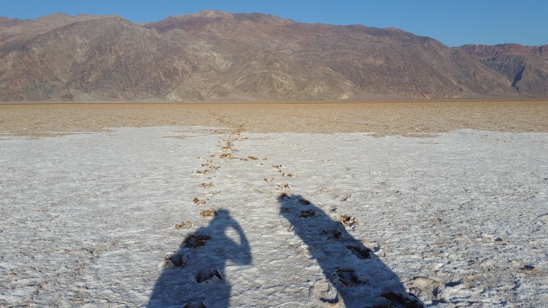
The salt flats were novel so it was fun despite the hard work getting over all the odd angles of crusty Earth formed by the mud cracking and then the salt rising up in between the cracks and forming into perfect hexagons, one of natures most stable structures. Beautiful. The terrain would change about every .5 mile to 1 mile from flat salt to crusty salt, to jagged salt and mud that tinkles like glass, to bumpy crusty lumps, to deep sticky mud with salt crust on top, that was a mess!


The mud completely covered our shoes and then formed a layer of salt over that as it dried. It was hard work walking in the mud. Eventually the distance to where we were going and the distance from where we came had switched places. When we actually got close to the Panamint Mountains and reached the dirt road, I checked my GPS. It had been exactly 6 miles, with an elevation gain of approximately 20 ft. Finally we made it across the basin to Hanaupah Canyon Road where we cached water yesterday. It was easy to locate and intact, yay! Water…found.


We stopped there for a 30 min break and I was definitely ready to eat something and sit down for a minute. The sun was sinking behind the upper peaks and so the evening temps were dropping to a much more comfortable level. Now, we each had to add 4L of water to our packs, and start the gradual climb. I was grateful for this cache location and the fact that we had 6.4 miles of easy walking to start out, because now it was going to get nothing but harder. Still, it was late enough in the evening that we could only go so far without night hiking. We set off with the goal of making it up Hanaupah Canyon dirt road at least a few miles before stopping for the night. It was still a sweaty walk uphill.
By about 8:30 pm we called it quits. The sun had gone away, there was barely any light remaining and we didn’t want to night hike. We glanced in every direction and all there was to see were rocks. But the rocks had a really cool flat arrangement and it was actually easy to locate a flat enough spot to make our beds. We were about 1000 yards off the dirt road, not far from a dry wash. I investigated the wash, and it was full of scrubby bushes and large boulders, no place to sleep there. I scanned the area around me in a 360 and I had this feeling that I was in the most middle of nowhere place that I had ever been, and that was the BEST feeling!
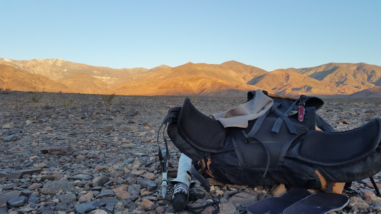
We set up our beds and dumped our gear out on the ground. It was time to eat! I had pre-soaked my dinner of couscous and beans and it turned out really delicious. I ate chips and a tortilla with cheese too. I drank about 2.5 L water since the afternoon, and anticipated way more for tomorrow. I calculated I had about 5+ L remaining for the next half day, including coffee and breakfast, and the 8 mile climb to Hanaupah Spring.
Journal Entry: 9:46 pm. 75 F. At the moment we are cowboy camping in the middle of this vast open space, it’s warm out, super warm, I am wearing a t-shirt and the breeze feels soft and luscious against my skin. The moon is 25% full yet it gives off a surprising amount of light. We are laying on top of rocks that you wouldn’t think would be comfortable, yet they are fine. The crickets are chirping here, the stars are bright and crisp like lasers and the sky is so incredibly vast in every direction. Everything out here is vast and I realize that being in this giant space, one that seems to go on forever and end nowhere, is completely comfortable for me. I love it here, and it feels like I am exactly where I am meant to be. I want to freeze this moment, suspend this feeling, it is the best feeling I can remember having in a while. I feel so completely open and free. There is no reason to have fear here. There is no boundary between me and the space. Even if I were out here completely alone, I would not feel afraid. I feel completely safe in this overwhelmingly large Universe. I am just a speck in it and yet I am all of it at the same time. What a feeling….I want it to last forever.

Mary Poppins!!!!! So happy that I get to follow your L2H posts! I missed your writing (and you!) Love it!