
Day 7: April 26, 2018
In the middle of the night the wind completely stopped and it got really quiet. It was warmer than the night before because we set up the tent, and I was thankful for a much needed better nights rest. We set an alarm for 5:00 am since we were not quite as far along as we had hoped to be. Yesterday, we traversed 20 miles, which helped us get closer to Lone Pine, but that still left us with about 15-16 mi to get there this morning. Of course we were trying to get there as early as possible because we had a bunch of chores to do. Gotta Go!
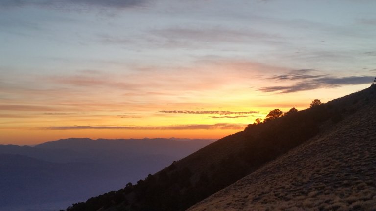
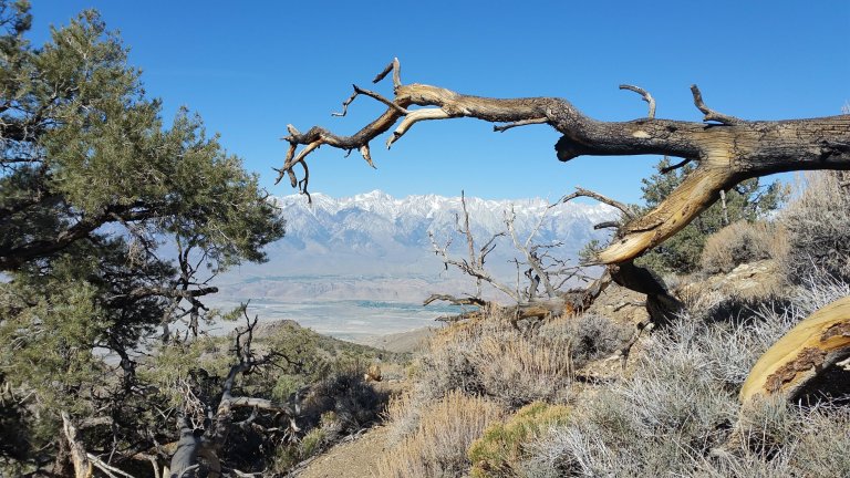
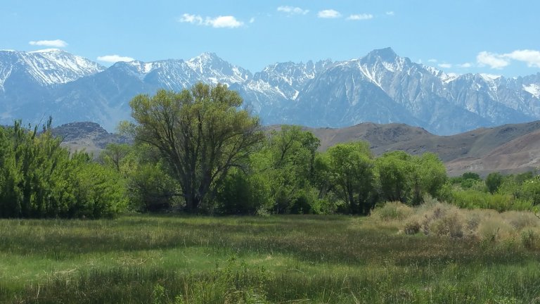
The morning was beautiful and we watched thin gray clouds turn to crimson oranges and pinks as the sun lifted itself to start another day. The morning light hit the Sierra massif as crystal clear blue skies emerged like paint spreading on watercolor paper.
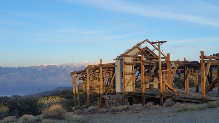
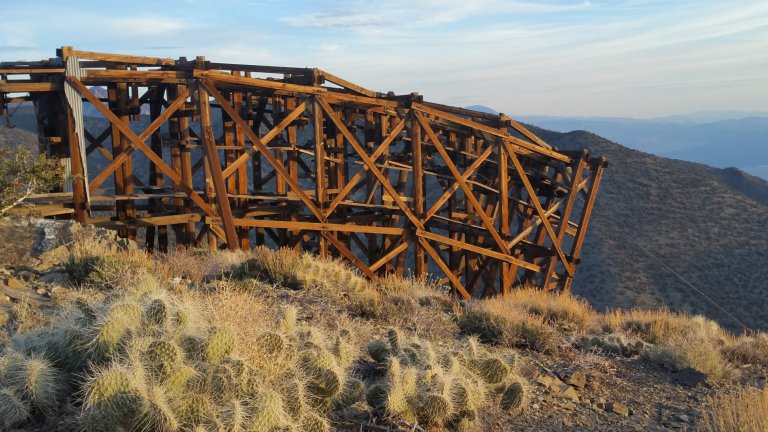
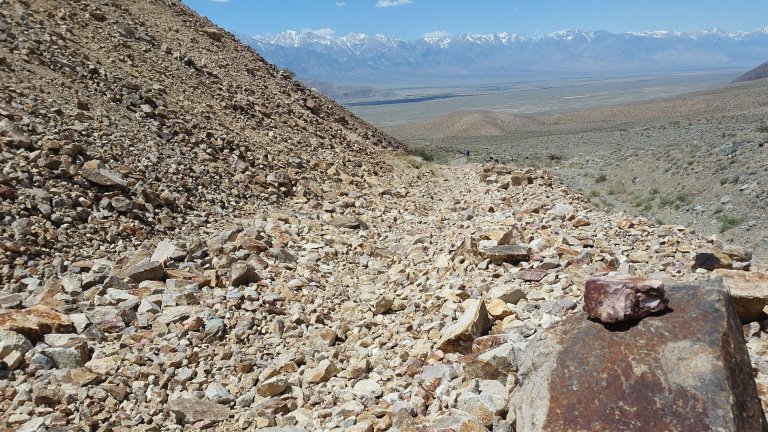
It was about 6:20 am when we started walking. We climbed about 700 ft on rolling hills made of dirt track roads and soon I was in shorts and a t-shirt, sweating already at an altitude over 9,000 ft. We walked back through the Salt Tram to get a better look at it in the daylight. What a project! It amazes me the fortitude and perseverance people had in those days to create such a thing, just so they can pull salt up from the desert floor, haul it over this mountain, and deliver it to the Owens Valley below. It’s nothing short of amazing!
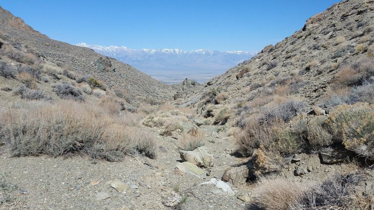
After the climb, we knew we would start to descend…and I mean descend, from 9,000 ft all the way to 4,000 feet in one swoop, barreling down the Inyos! Now that is all fine and dandy when you have a trail to follow and you can cruise at 3 mph or more, but this is the L2H, that pace would not be possible.

First we turned Southwest and started a cross country descent of some loose talus mixed with dirt, sand and larger rocks. We plowed through sage brush and the same poky things that have been scratching my legs all week, what are they anyway? Navigation proved to be somewhat challenging for me now, because we opened up into this abyss of canyons, washes and cliffs that all seemed to generally point West. Which canyon will we go down? I wondered. What obstacles will we have to divert around?

My GAIA GPS has been acting a little funny all week and I hadn’t realized that I needed to download the offline maps when I had Wifi, so my maps sucked with a capital S. That means that I never really got to navigate with my GPS, as the maps did not load and all I could see was the red line that connected the dots of GPX tracks.
I pulled out my low quality paper maps and compass many a time, but I still needed to know my location. So I would orient with my paper maps and compass, then check my location and see if I was to the Right or Left side of the red line on GAIA. Then I would compare that to my paper maps again and try to figure out which contour line, ridge, canyon or wash to follow, or simply which direction to set my compass bearing to.
At the end of the day, the GPS rules the show. If you are way off route, you will end up way off course in the big picture. Out here, you really can’t afford to play around with getting off course due to the fact that it’s 90-100 F and you are carrying only so much water, and there is absolutely no shade. L2H at it’s finest!
Hurlgoat was well ahead of me and I didn’t know how far, I also didn’t know when he may stop for a break and wait for me. It’s a very strange feeling to look out over these mountains and know your hiking partner is out there somewhere, but you have no idea where. Will I find him? By 10:00 am I was really getting hungry and wanted to stop to eat. But I pressed on, determined to catch up with him. I needed us to be doing this together.
I kept thinking, if we take different routes down this mountain, and if he decides to stop to wait for me, but I never materialize, he will get worried. He will perhaps go back up to look for me, but I won’t be there. He will run out of water, and that is dangerous in this heat and exposure. I won’t know that he did this and when I get to the bottom, I will wait for him too. Then, I won’t find him. I will wait and wait. I will wonder. It will be so hot and I will be so thirsty. We will spend the rest of the day trying to find each other and possibly fail.
This head space was not good. Morale was deteriorating. I needed to stop and eat, but I couldn’t. I followed faint footpaths that were also occasionally marked with cairns. You really need to look for the cairns and the terrain keeps changing every few minutes. Soon you find that you are way in over your head as far as the terrain goes, it becomes really slow, tedious and difficult. This is not the route, the route is challenging but it is not meant to be the path of max resistance, it is meant to have some sort of flow and make a little bit of sense.
Eventually I ended up following a faint trail up above an attractive wash. Then, effortlessly, I dipped down into the wash. It looked to me like this wash was going to flow along right down the mountain and the walking became so much more pleasant. So I pushed on happy for the easier walking. I’d dropped down about 500 ft when I heard Hurlgoat howling for me. This is how we locate one another, we howl like wolves, and usually it works. Owwhooooooo!!
I knew the walls of the canyon to the North were not where he was, but this was where his voice bounced off of. Because of this, I figured he was well above me and obviously we were nowhere near one another. Shit. I looked at my GPS and realized I was down in the wash when I was supposed to be up on the ridge. Damn that last 500 ft I just dropped down. I went the wrong way. Again.
I looked up and decided to shoot straight up, connecting the shortest distance between two lines. I bush whacked it all the way, sweating and heaving like mad. I finally made it back to the route and was able to confirm it by seeing that I was back “on” the red line on GAIA. I followed the ridge Westward until I was well above the wash I’d just climbed up from, and eventually found Hurlgoat sitting on the slope, taking a break, in the full sun.
It was so damn hot. The sun was so intense. There was no shade whatsoever. I’d forged up, up, and up and was so hot and irritable and cranky and hangry by the time I found him. I’d spent some time brooding over the fact that he was no where in sight, and I hated to be in that position of not knowing if we were even on the same route or if we would find each other again. I was actually pretty mad and I told him so once I found him. Eeeek!
I didn’t like being this way, especially to him, but I had to let it out. Mainly, I was upset because in my opinion, this set of circumstances could be a very dangerous situation if we had lost each other. If one of us got so far down the wrong canyon, one that eventually lead to massive obstacles where you simply cannot get through, and therefore had to back track, how would the other person ever know? We had not established a meeting place or time, which would have been smart. When you are on a trail, it’s no big deal to get separated, but when you are on a cross country route, it’s a whole other animal. In retrospect, I can say that going through this process was necessary, as I learned a lot, but sort-of the hard way.
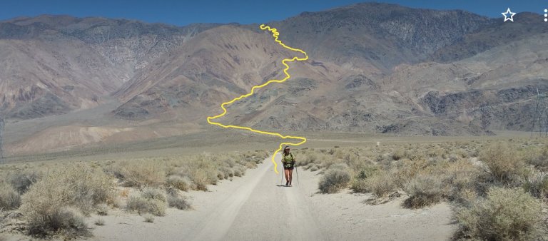
We sat in the sun eating lunch, I popped open my shade umbrella, as the sun felt like it was melting the skin off my legs and feet. Ouch. Turns out Hurlgoat did the same thing I did, and overshot the route, dropping into the same wash as I did. He too, had to backtrack and go back up. It’s definitely not easy, finding the way. We left the lunch spot together and I demanded that we stay in sight of one another for safety and time purposes. The route got confusing again and we overshot it to the South once more.There are several faint trails out there, from other people, or from animals, but they don’t all lead you where you want to go.
We should have followed the spine of a ridge to the West, but ended up walking across a ridge to the Southwest and had to back track. Again. The straight line down to the wash below where we needed to be led us over to some big chunks of rock, more sharp things and more loose rock. Eventually it was just a matter of literally sliding straight down the slope to the wash. It was like skiing on talus rocks that collapsed under your feet with every downhill step on a 30 degree slope. This is definitely not my favorite terrain.
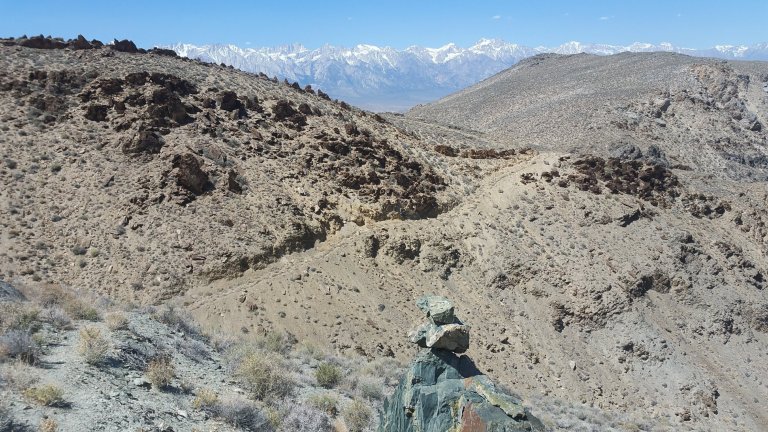
I took it slow, and was not feeling confident at this point. Hurlgoat just plowed down, super fast, and this irritated me because I couldn’t keep up. Once at the bottom, thankful it was over, we followed a long wash with lots of sand and boulders that eventually led to a wider canyon that led to a sort of dirt road. Sort of is the operative word, it was not something that any vehicle could drive up, but at least it was a track to follow and not get lost. We found another mine and we went inside to cool off for a few minutes. It was so damn hot and the water we were slurping up was hot too, so unsatisfying. No amount of warm water will ever quench your thirst. Eventually we followed the dirt track which turned more and more into the dirt roads that were easy again to follow and keep a 3 mph pace. Finally.
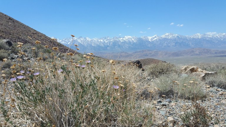
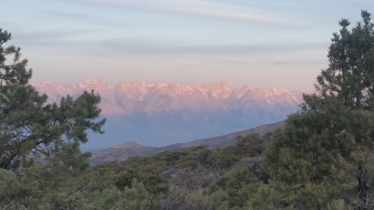
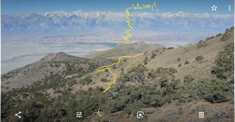
Despite all my frustrations, the entire day we were blessed with stunning views of the Sierras and often would stop to stare in awe and examine Whitney from this completely original vantage point. I would stare at her, knowing I am headed “up” there, all the way there, it was initially so far away, and now, with every step getting closer and closer, it was tangible. We passed the 100 mile point on our trek today. So Crazy.
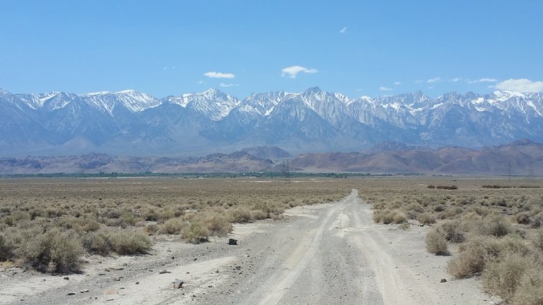
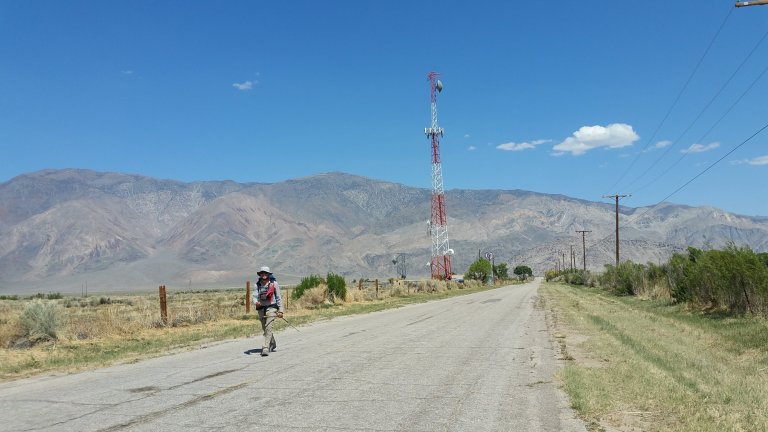
From above we watched the town of Lone Pine get closer, the landscape became greener and these sights churned up excitement for things like a/c and ice cold drinks, and perhaps…just perhaps…a shower?

Town now seemed so palpably close. All we had to do was walk down the dirt road and we would be there. Well, we failed to remember that there is also the Owens Valley to cross first. It never seemed as intimidating as Badwater Basin or the Panamint Playa, but it was probably just as far. It’s landscape was less alien, so perhaps that made it more approachable, compared to walking into the great abyss of Death Valley.
We trudged onward. The walk across Owens valley and to town took what felt like for-ev-er. We ended up on black pavement for at least 3 miles and that was faster walking but was hotter and harder on the body. Temperatures had reached the triple digits by then. We took photos of the Inyo’s behind us, remarking on how crazy it was that we just came down out of that massive range in a matter of hours! They are impressive, it was impressive, what we just did, I’d never done anything like it. It wasn’t easy, but I was still in love with this hike!
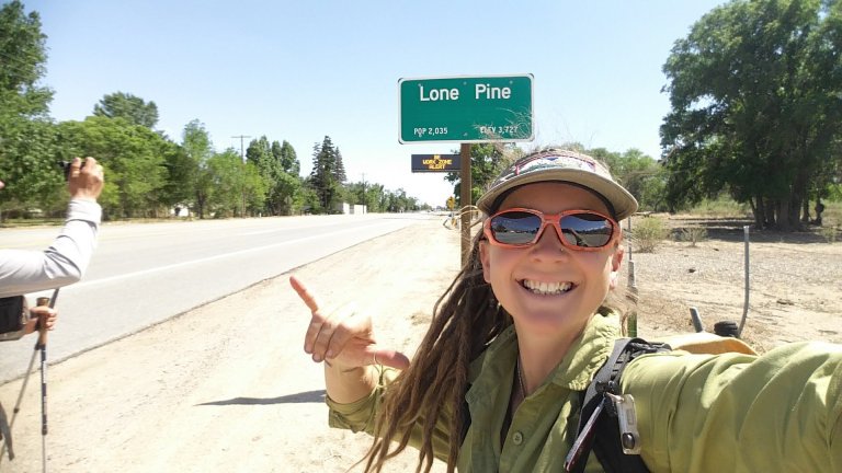
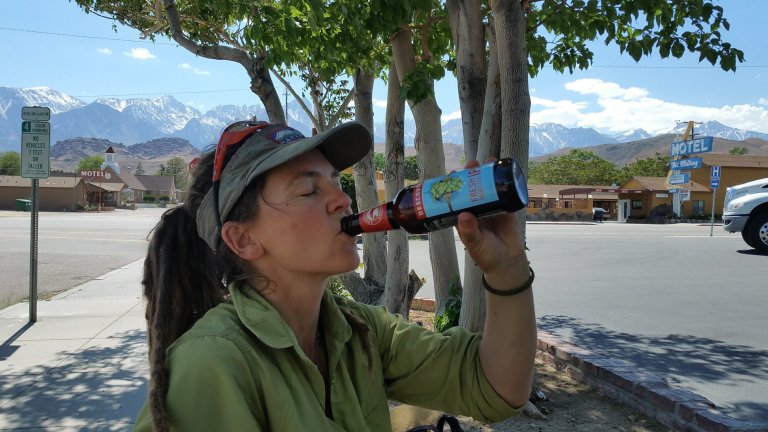
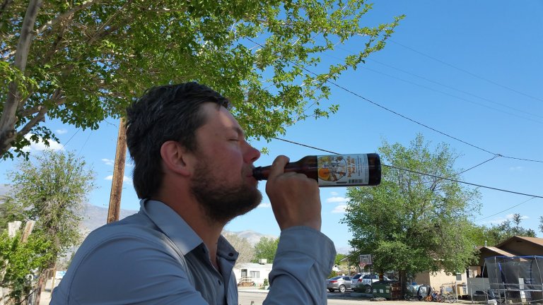
Finally we were on a tree lined street where there was a creeek nearby and the world smelled of wisteria in full bloom and fresh horse hay. It was hot as hell tho. We really had to push those last miles and we made it to town by 2:30 pm, walked down 395 for a mile and then went into the Chevron, bought a couple beers and sat outside in the shade drinking them with our shirts off.
Hiker trash at it’s finest.
Once we were there, we realized how much stuff we had to do. We needed our Whitney permits and the Eastern Sierra Interagency Visior Center closes at 4pm. We didn’t have time for a 2nd beer. So immediately after the beer, we went to get my car and went to get our permits. A totally painless process, and free thank you very much.
We then went to The Grill and ate pasta and drank water. It was then that we decided that it was going to be quite a late hike through the Alabama Hills if we left that evening as originally planned. We were looking forward to the Alabama Hills Alternate Route, with the great rock formations, wildflowers and views of Whitney from Mobius Arch.
We then conceived of a plan which involved getting the guy from the gear shop to follow us up to Whitney Portal in our car, so we could leave our car there along with all our snow gear. THen, he would give us a ride back to LP and that night we would splurge and get a room, yes!!
We checked into our room at The Dow and rewarded ourselves with all the nice things that come with getting a room. Unfortunately, we missed the laundromat and then the power went out, but hey, we got a shower and a bed, and it was marvelous. I was in bed by 9:30 pm but Hurlgoat had to go back out to eat more food. He went to the taco truck and by the time he got back I was sound asleep. Oh my sleep in that bed was so wonderful, I really really needed that! Tomorrow, we are bound for the Alabama Hills and then on up to Whitney Portal, we’re getting so close!

Thank You MillissaJayn for additional interesting and informative narrative and imagery from L2H Trek. Especially appreciate your candid observations regarding clear route/path communication between two individuals navigating within the difficult and varied physical terrain you encountered.
Your previous L2H thoughtful writings and images are inspirational and informative.
Thank you for taking the time to make them available here, hope that you have a fantastic Spring/Summer 2019.
Hi William, thank you so much for reading and I appreciate your commentary, glad you find it inspiring and informative! Happy Trails 🙂
wow. This is so thrilling to read. I’ve watched the videos and loved them! But your words are capturing some of the struggle …and heat….that we don’t always pick up in the faster moving vids. Your honest writing is mesmerizing. And the photos with the yellow highlights truly show how far you two can hike in a day. And a day of extreme heat. Amazing. Puts the ‘awe’ back in awestruck. Can’t wait to read more of your blogs. Darn work and household chores keep getting in the way, though, which is so rude. 😉
Oh thank you so much for your feedback. It means a lot to know others are getting something meaningful out of what I share. More to come!
Beautiful.
A mirror to the soul.
From the hot boiling sun onward to Mt. Whitney where its cools way down. Ms. Poppins, your blogs are soo awesome and the pictures, wow! Thank you again for these blogs and I agree, gps can suck big time when they do not work right. Besides that, a couple of years ago, my dad and I went to Scottsdale, Az. and went on a biking trail but boy was it hot! However, I will treasure the experience. Besides keep reading your awesome blogs. Thank you again Ms. Poppins.
Hi MelissaJayn:
I found your blog after watching some of Hurlgoat’s marvelous videos on the SHR and L2H trips. Your writing complements his videos nicely, filling in details that don’t come across in the video. I’ve been spending evenings enjoying your adventures vicariously from my living room couch. I hope you will post your reports on the last few days of the L2H trip.
With regard to separation anxiety, my hiking partners and I carry HTs (walkie-talkies), so we’re always in easy communication. Although it’s another (small) thing to carry, it has come in handy a few times to check-in when we’re out of sight or when the way is uncertain: one can go ahead and give report, saving the rest from wasting time and energy if it’s a dead-end. Easier than yelling or hollering, although maybe not as cathartic. Since two of us are licensed HAMs we can use any nearby repeaters (2m or 70cm) to increase our range or to summon help–haven’t needed to do that yet–if we’re having an especially bad day.
Hi Bill, hey cool, thank you for reading and commenting, actually this motivates me to get those final posts finished for the L2H! Ive been since chipping away at my AZT blog, so got swept away with that! Yeah, walkie talkies would be great on routes like that, haha, but truly I now know, its more important to establish communication plans and strategize together. Glad you are enjoying HG’s videos, he does such a wonderful job!