
October 9, 2018
Blue Lake Pass Vicinity, Elevation 11,044 ft
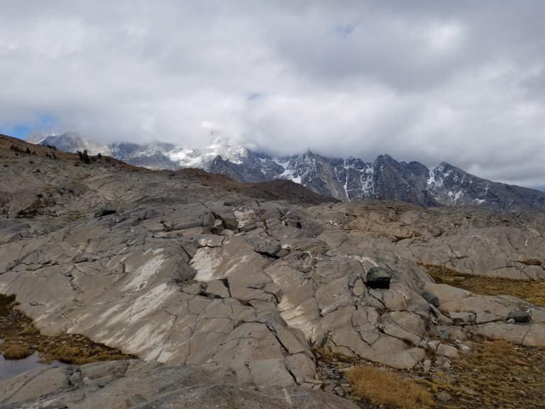
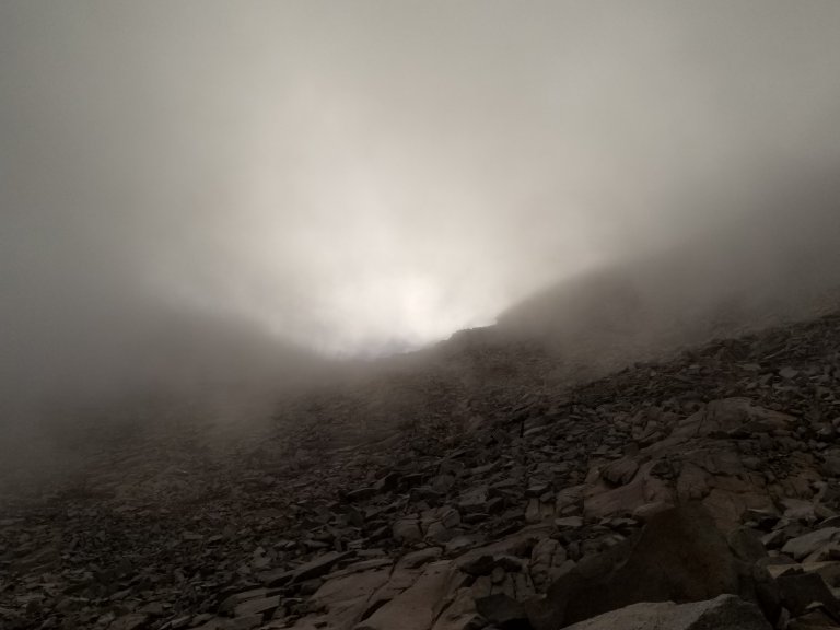
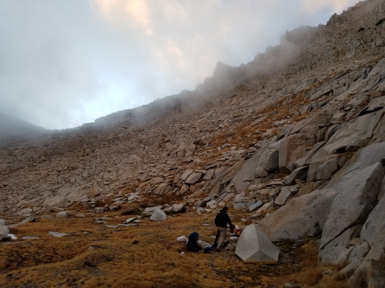
We are camped .2 miles and about 200 feet just below Blue Lake Pass. We got lucky actually, with the fact that there is a place to camp here, and water too. We made the call at 6:00pm to stop here, knowing there would be a boatload of talus to negotiate on the other side of this pass, and we are unsure how far and what type of terrain we will face over the next few miles where we would have camped. I am so thankful that we have this spot. We are at 11,044 ft here and we are in a cloud. Literally, we are in a cloud. It is about 33 F with mist in the air that makes it feel a lot colder. I am so glad to be tucked into bed, and about to close the door to the tent and get rid of the frigid draft. Speaking of frigid, let’s talk about this morning.
I woke up, as usual after Hurlgoat, at 7:00am. Dang it, I really didn’t mean to sleep that late, but I was so cozy and warm. Time to get up and get moving, I think as I try to rally. Suddenly I realize I need to poop and that is always the last straw for lingering in bed. I get out of the tent. All around us I see nothing but rock, rock, and more rock. And it’s all covered in frost. I can’t skip going to the bathroom though. Dang it! I’ve been in this situation many times, and somehow it always seems to work out, so I don’t panic and instead, begin making my way precariously across the slick rocks, up a hill.
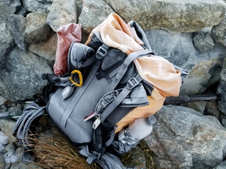

So Hurlgoat suggested we just get going right away, since we weren’t going to see any sun for a while, and rather than sit there freezing over breakfast, we could get some talus hopping in and take a break in the sun later on. I was not super excited to skip coffee and breakfast, but willing to do it, since it really made the most sense. My pack was absolutely covered in frost, stupid me left it siting out all night, with nothing to protect it, what did I expect? I started changing into my day clothes inside my sleeping bag to keep warm, and choked down a couple of bars that were way too hard to be eaten.
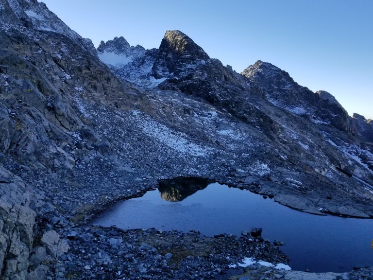
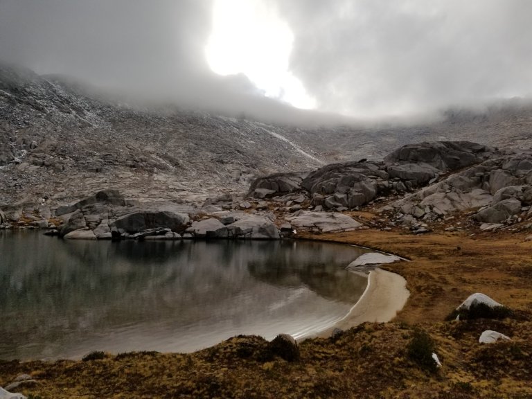
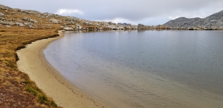
We made such an effort to keep our shoes from freezing last night, we slept with them inside our sleeping bags, and while they were still wet this morning, at least they were not frozen. The first thing we had to do once we set off was walk around this little tarn nearby where we camped. Hurlgoat takes the lead and skirts the absolute margins of the water, teetering on some rocks and stretching to make it around to higher ground. I am thinking it doesn’t look good. I bawk a little at his choice and while I could have found my own way around, it would have taken way longer and I didn’t want to make him wait already. So, I followed suit. I began following the same steps he had taken, only to discover that the length of step was just a tad too long for me, and while precariously balanced on a loose-ish rock, trying to figure out which step to take next, the rock dislodged and plunk went my left foot. It splashed and also got my right foot wet too. Dang it. I was so mad, I ended up walking straight through the water to get to the other ledge.

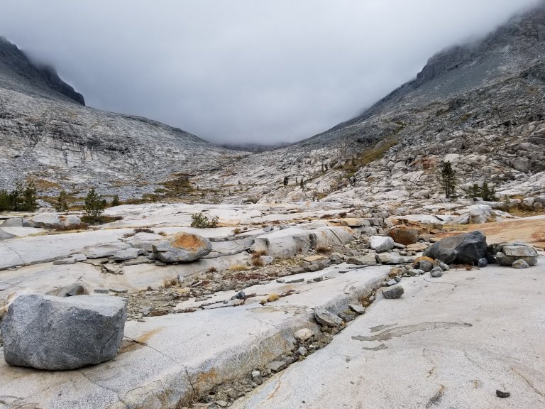
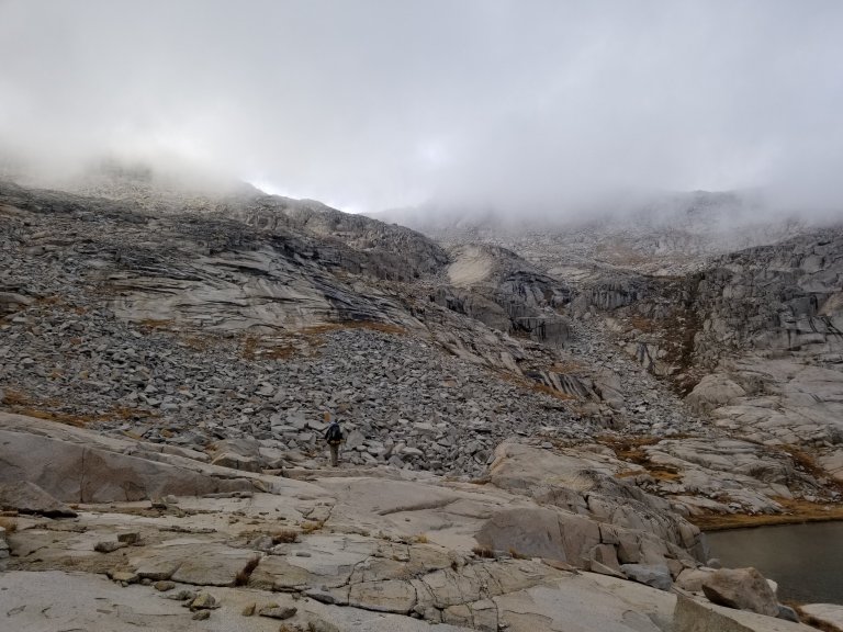
I was pissed, first no coffee, then this! The morning was so cold, and I knew we would be negotiating some quite technical terrain that may also be icy, and with wet frozen feet that just wasn’t going to help. But, what could I do? I decided my feet would have been cold anyway and by lunchtime I know it would be much better. We walked around the edge of the little tarn and followed along a cascade, and down over talus that was sometimes covered in frost or black ice and sometimes nothing, but you could not tell just by looking. Now it’s time to play the game, “is it icy or is it dry?” and with each step I would tap my toe, test the grip, see if it stuck or slipped and proceed. Tedious, and treacherous!
Much of the time, I find the guidebooks use the statement “choose your own adventure”. What this really means, is “go whichever way you want”. Now, that can be seen as hiker freedom, and it can also be frustrating when you try something and it doesn’t work and you have to backtrack. Or it can be seen as “we don’t really have a suggestion here”. At least that means it is “safe” to go which ever way. But what the “choose your own adventure” often translates to is confusion. Again, navigation on this route proves to be challenging. We use Roper’s book, Skurka’s maps, our downloaded GPX tracks, and now we’ve added Double Tap’s notes. We have a lot of input, but dang it is still really hard! We mentioned at one point today, that if we didn’t have the GPX tracks and only the map and compass, with the notes, we would not be getting anywhere!
We next had to scramble down what Roper called class 3 cliffs that Double Tapp said “look scarier than they are.” We’ll see about that, I think to myself. In Roper’s description of this section he states that “hikers should consider having the most experienced person in the group reconnoiter the next section while the others wait for the verdict.” Nice. So that means since Hurlgoat is bigger, stronger and less afraid than me, he goes first!
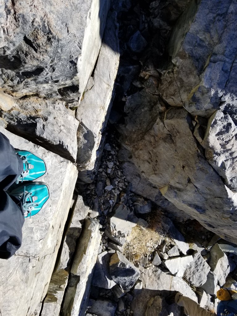
Looking over these cliffy ledges wasn’t all that bad really, it’s just very awkward lowering yourself down, with your pack on and trying to find a place to put your foot where you can’t see. It was a really long reach for me and I was glad he was there below me in case I slipped. There were enough other rocks nearby that I could use both hands and lower my body down slowly. Precarious, yes, but definitely do-able. So here we are again, what exactly is the definition of a class three? So, like Double Tap said, it was actually not terrible.
By the time we’d arrived at this area, the sun was reaching the rocks and it’s warming beams had also found us. It’s warmth really helped lift my spirits, it was just what I needed. Remember that song “I think you’re just what I needed” by The Cars? Let’s hear it for the 80’s !! We continuted to descend across lots of talus, but now we were in the sun so the slippery ones were only occasional. It was really nice to be able to boulder hop and step with confidence. We even picked up some areas that had dirt and grass, making little trails, hooray! I tell you, I am so sick of talus. After this hike is over, I am going to avoid it like the plague. Those little segments of dirt trail and grass give me so much joy, but they last literally 30 seconds or a minute at most and then you are back on the granite. There is so much frickin’ granite up here!
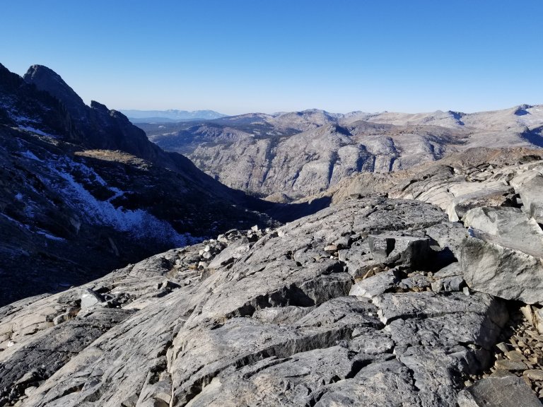
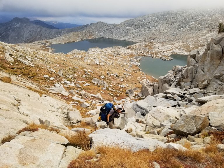
But, what I will say here, is that we earned some of the best views I have ever seen in my life. I think I said that also yesterday. Again, we were treated with an absolutely stunningly beautiful day today. After the technical stuff, we were able to contour around more grassy ramps and slabby stuff, with only occasional class 2 and talus. Eventually we made it to the Twin Island Lakes, which have a very austere feel to them. In every direction all you can see is granite, of all colors and textures: reds, grays, blues, whites. It truly feels like we are out there. I love this!
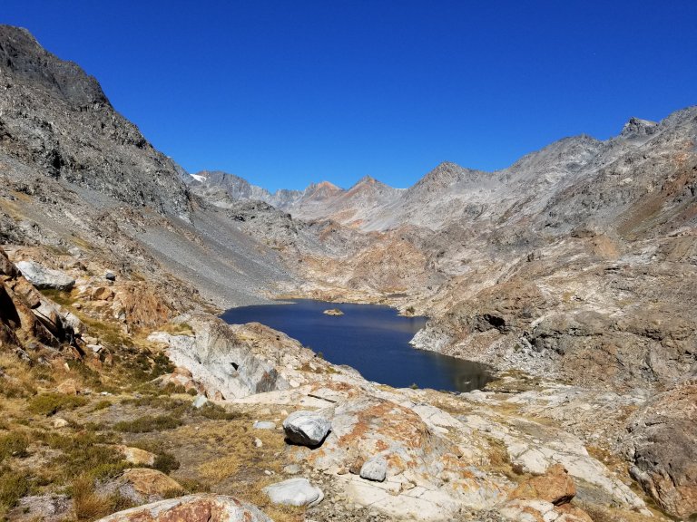

From Twin Island Lakes we skirted around the far side of the South Lake which was tremendously beautiful, and from there we climbed up and over a hump, then descended to a little meadow with a tarn. It was time for lunch! So happy to stop and take a break, and more than anything, I needed to dry out my gear. All of our stuff was soaked from the frost and condensation of the morning. We were very fortunate beacuse the sun was beaming down on us, as we watched billowy clouds build and begin to move in. The clouds were “looking darker than they should be” says Hurlgoat. I check my InReach weather to see what we are in for. “It looks like the coast is clear”, I report, and we feel relieved that we are not walking into another snow storm. We have lost some time on this week’s trek, first due to the snow storm, then due to lengthy snow covered talus fields that take forever and a day to get through. Our mileage had been pretty low, and I know part of that is me, I am just slow, well, slower than he is, but the weather was not exactly helping.
Speaking of slow, after lunch, we climbed some nice grassy ramps, and made our way up a slope that gave us even more tremendous views of the Minarets. They were dusted with snow and surrounded by puffy, swirling clouds. We took our time and stood there in awe. Where are we? It’s almost overwhelming, all the granite, all the space. How did we get here? It’s surreal and almost like an out-of-body experience. Then, wham! reality strikes back, we have more talus to negotiate.
The next hour was punctuated not only by talus, but some big slabs, more climbing, and then contouring on talus and a faint trail. We were gaining altitude and finally found ourselves climbing/scrambling up to a “notch” as Roper calls it, but it wasn’t a notch in our opinion at all. Nevertheless, from this “notch” we were able to follow a faint trail down a steep slope that led us down about 600 feet or so to a valley that is like paradise. (Que the 80’s music….)
This valley is called Bench Canyon. It’s interesting, all this terminology. There are “gully’s” and “ramps” and “tarns” and “slabs” and “valleys” and “canyons” and “escarpments” to name a few. Apparently the long slope leading down into Bench Canyon was considered a “gully”. Could have fooled me. It looked like a big old slope to me. Anyway, I digress. We reached Bench Canyon and enjoyed strolling across flat, grassy land, with big smoothe granite slabs that had little cascades of water rolling down. The grassy meadow was interspersed with little creeklets that snaked the clearest water to and fro. We started from there, to climb up into a forest of Whitebark Pines, and some old lodgepoles with old souls. This ascent was quite pleasant and a nice grade, especially compared to a lot of the grades on this route, which are basically sraight up. This was a climb to be sure but it was lovely. I was grateful to be on “land” and the ability to simply walk and think and look and feel were welcome.

We made our way to to Blue Lake eventually, watching all the amazing clouds and mist build, dissipate, change shape and billow, as clouds do, around the surrounding snow dusted peaks. Absolutely stunning scenery, lighting and weather changes. We couldn’t have asked for anything more special unless a Unicorn suddenly appeared. In Roper’s book he describes this area as “a fairyland setting” He goes on to describe the myriads of wildflowers that one encounter’s here, however, not so much in October eh? This is the best quote though: “Amid such splendor it is nearly impossible to avoid cavorting like a child”. Am I right?
So, there we were, cavorting like children around Blue Lake and it’s surrounds. This section from Twin Island Lakes to Blue Lake Pass is defined as one of the most untrammeled sections of the entire Sierra High Route. It was certainly an honor and a privilege to be there. I wanted to stay there and absorb the great energy and lounge around staring up at rocks and sky. Alas, we had to keep moving. It was just after 5:00 pm when we began the 700 foot steep ass climb up to Blue Lake Pass.
I was feeling a tad bit nervous about how late in the day we were beggining this climb, and while Roper’s book indicated that it was a fairly easy climb, Double Tapp’s notes indicated that the other side of the pass was nothing but talus, talus, talus. That sort of gave me anxiety. I had visions of descending talus into the night, thinking “great, not only have we hiked miles and miles on talus, we have hiked talus covered in snow and frost and now we get to add talus in the dark- which also might have snow to boot”. No thank you.
Nevertheless, we were climing up toward the pass. It was steep, very steep. The kind of steep you just dig in with the tips of your toes and try not to stop or you may fall backward. It was straight forward though, for the first 500 feet up to a flat bench at 11,000 ft. From there we were not entirely sure we had gone the “correct” way. Choose your own adventure, right? We wanted to ensure that we were not going to overshoot or miss a chute leading to the pass, because we were now running out of daylight.
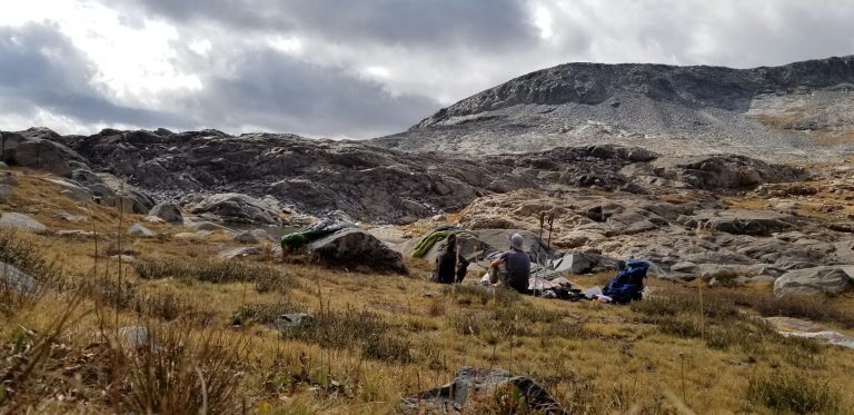
In fact, upon reaching this ledge, the first thing I thought, was “we could camp here”. We are very fortunate there is a tiny little pool of water, and that was enough to use a scoop with. Done and done. I made the suggestion to Hurlgoat and he was glad I did. We are choosing to adventure over the pass and down the talus in the morning. I hope the clouds will part and afford us tremendous views. Or at the very least, I hope we will be abe to actually see the pass because right now we can’t see shit.
Tomorrow we need to make miles, we are feeling a little pressure. Hurlgoat is also out of cooking fuel, and I am very low as well. I’ve got enough food, but truly, we are feeling the end coming close. When I look over the maps, it looks intimidating how much terrain we still need to cover. Yet, today we made 9.5 miles and we have 25 miles to go. Tomorrow, it looks like we intersect some trails and will be using them for several miles all the way through Yosemite and Tuolomne, so we are banking on being able to make up some miles on trails. I hope we are right!

Keep it going woman!