
September 23, 2018
Bishop, CA Elevation 4,150 ft
The middle of the night might as well have been daytime, the moon was so bright, with nothing to shelter us from her luminosity. I had many strange dreams, and Hurlgoat was up in the middle of the night, unable to sleep. I heard him get out of the tent at one point, and while I was awakened, I could not muster my own motivation to join him for sky gazing. Still, I thought the stars and the night sky must have been a sight for a weary soul. September 24 is the official Full Moon, the Harvest Moon, which brings the energy of reaping the fruits of our labors we have been working so hard at since the Spring.
I wonder what I will reap this month whose seeds I planted months ago?
I pause to reflect on the energy, which is what the Moon in her Fullness wants us to do. It just so happens that this full moon is in my sun sign, Aries. What does that mean for me? It means, that instead of focusing on the typical Aries things like forging ahead and taking charge, acting on a whim and pushing pushing pushing, I am to slow the heck down. It’s interesting then, that I am here, now, doing just that. Yes, I am still charging up Mountains, but well, let’s face it, it’s not exactly charging. It’s more like crawling.
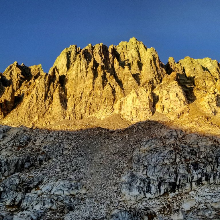
North Palisade Cluster at Sunrise
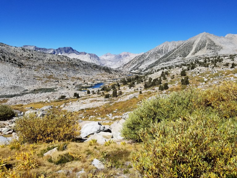
I managed to doze off again and woke finally at 7:00 am, eager to see the sunlight hitting the wall of North Palisade and it’s mirror in the water. I made coffee and chomped on the last of my home made cookies for breakfast, while sitting outside but still tucked into my sleeping bag. The thermometer read 30F and it felt like it. We talked over our options for getting into Dusy Basin, which were either Knapsack Pass or Thunderbolt Pass. Knapsack was the official SHR via Roper’s and Skurka’s routes, and Thunderbolt was listed on our GPS tracks for some reason. It was like that decision we had to make regarding either Frozen Lake Pass or Cartridge Pass. Not clear why the person who made the GPS tracks went the way they did, veering off the official route, we decided once again to go with Roper’s and Skurka’s official route. Albeit, this route was described as being a little more circuitous than Thunderbolt, which was entirely direct; Knapsack seems less technical, much less steep and hence probably faster than a direct route over unknown terrain. The footnote on Thunderbolt Pass notated a much steeper and very bouldery descent, and we now know how that goes!
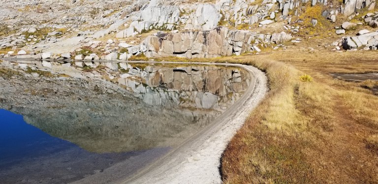
So, Knapsack Pass it was, a simple saddle at 11,500 ft only a mile away, with the second of the two Barrett Lakes in a hidden from view depression along the way. By the time we’d made our decisions and began packing up for the day, the sun arrived above the craggy horizon and immediately forced us to layer down. Our gear, and especially our tent were frost-bitten, and so the sun allowed us to dry everything out at least a bit. By 9:00 am (this is the new 7:00 am) we were off to walk around the shores of Barrett Lake, the lake that gifted us that delicious trout last night. Thank you little fish for giving us your life!
No sooner had we walked 100 yards were our cameras out and snapping away at the still as stone reflections on the water. Not a single whisp of a breeze presented itself, and when you looked West, it was one of those vantage points where you cannot tell where the water ends and the sky begins. On the margins of my mind there lies a horizon made of Earth, but I cannot tell you how far it stretches, for it appears to run on into infinity.

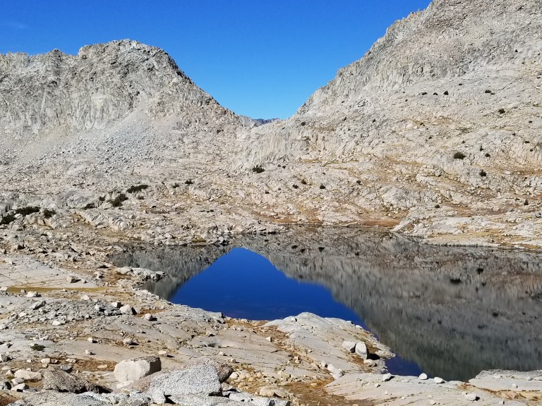
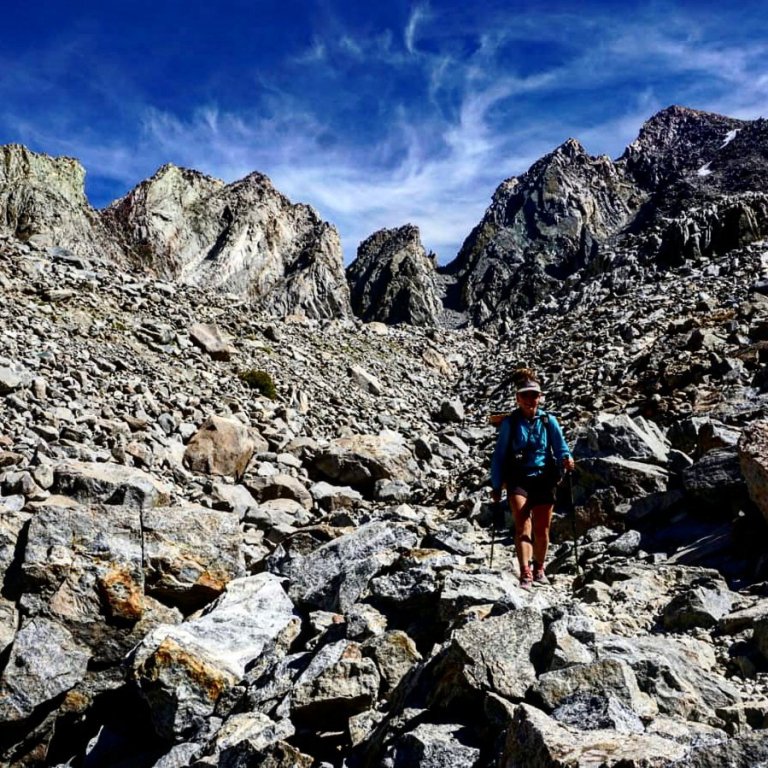
We strolled along the sandy shoreline and soon found a faint trail leading up into the hillside where we would begin a short climb. Always in the mornings, my legs take time to wake up, and today I feel like my thighs have been doing some good work. They do not feel weak, but strong, only slow, as we climb closer to 12,000 ft. We try to stay high on a contour line that would naturally bring us to just beneath the pass by maybe 100 ft, but the terrain gets a little more technical than my body wants to take on so soon in the day. We re-route, taking an only slightly backtrack route to descend, so that we may climb more easily, less technically. Always, the rule of the mountain is this: to go up you must go down; to go down you must go up. This is a universal constant that one can always rely on to be true.
What other truths do these Mountains hold?
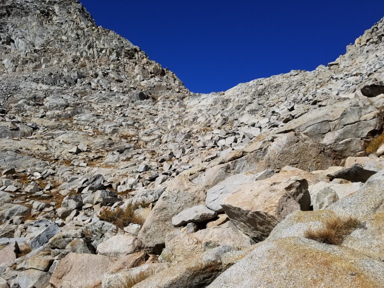
We dropped quickly down a rocky, grassy slope, only to turn back and face uphill again. Scrambling to get back to the higher elevation, we reached a rock face that was steeply angled and had little to grip onto with either hands or feet. It was nothing crazy or risky, but I got up there, about half way on the rock and sort-of lost my cool. I suddenly felt shaky, like my body was not quite going to hold me, I’d lost my momentum in that still moment, and I was not confident that the granite was going to be forgiving and hold me. My shoes did not feel grippy, suddenly my palms began to sweat, and as I looked up to where Hurlgoat was, I couldn’t see where or what he’d used to grab onto and hoist himself up. He waited patiently for me, unaware of the intensity of the experience I was having, and started making a video of me trying to climb, narrating “here’s Mary Poppins in her element.” Meanwhile, I am struggling internally, the adrenaline is getting thicker in my veins and I’m thinking, he has no idea that I am even struggling right now.
I took a deep breath, determined not to let this get the better of me, I remained calm, and I was through it all within maybe 1 minute. Something in my brain had been triggered and caused me to have this minor emotional reaction, one that I was not able to control. I crested the rock and grasped for the grassy flat land, then upright, held out my hand to show him how much I was trembling. Understanding and processing the trauma that I endured earlier this Summer is still something I am clearly working through It shows up sometimes when least expected, and I don’t know how to get through it other than to wade through it’s unpredictable waters.
I was panting too, short, shallow and fast breaths, which is totally unusual for me, since my body is incredibly acclimated right now. Clearly this was a compensation reaction. I took several deep breaths and continued to walk, trusting it would pass soon. I’m certain the more I move, the faster this adrenaline will be cleared from my blood. So let’s go! Hurlgoat was talking and all I could seem to manage was “un huh” or “oh wow”…. But once we started climbing again, I fell back into more of a rhythm, and soon we were putting our heads together analyzing how to approach the last few pitches of this pass.
Roper does not give any specific instructions on climbing this pass other than “choose one of many options” to zig zag your way to the top. We were still finding pieces of worn dirt and flattened grass that indicated people had been there before, we would choose these most of the time, speculating they would lead to the easiest way up. Sometimes they did and sometimes they didn’t. Climbing the shelves of this pass proved to be pleasant and there were only a few more scrambles that involved my hands’ confident grip. The last pitch to the pass on the Western side was a marbled granite slab, perhaps a 30 degree angle, which you could simply walk up, not unlike that of Cirque pass yesterday. Pretty cool, who’d of thunk?
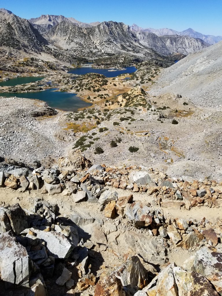
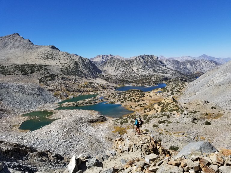
I was very excited to see what the views of Dusy Basin looked like on the other side, as I’d hiked through that area at least 4 other times, but always to and from the JMT/PCT and to and from the Bishop Pass trail. So, this was truly an exciting moment to see where we would pop out and drop in.
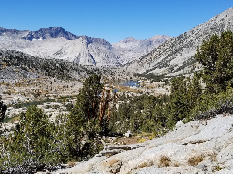
The views from the pass are second to none, just as so many have been, especially over the past few days. What I loved about this view was not only the Eagle’s eye vantage over the entirety of Dusy Basin, but the view all the way into LeConte Canyon, up through Little and Big Pete Meadows, Muir Pass, and the Black Divide. As the Crow Flies, or as “The Bird Crows” as Hurlgoat says it, you can see Muir Pass, which is perhaps 3 miles distant. By trail, it would translate into about 12 miles. These are my estimates, I have not fact checked this yet, but I think my guess is fairly accurate.
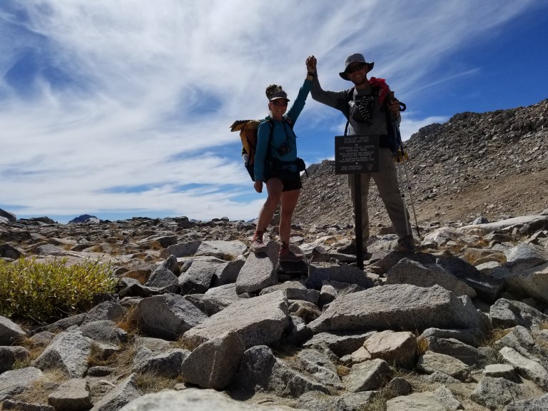
From the pass, we heard voices down below, a guy singing, and not long after that I spotted a human attached to that voice nearly dancing up the walls of rock we’d just come up. People! There were other people out here, who seemed to be walking the same route we are. By the time we dropped maybe 100 ft from the pass, the two, not just one, had caught up with us.
A young duo, “QueBee” (if I remember correctly) who had a long blonde braid and hiked in a skirt, had a pretty tiny pack, wore a newish looking pair of sky blue Altra Lone Peak’s, and had a DSLR camera clipped onto her shoulder strap. She said she’s been following my Altra footprints for a while! Her partner was “Evermore” or “Everlast” I don’t remember which (sorry!), and he too sported a very tiny pack, a red Aloha shirt and a grizzly looking beard surrounding a wild smile.
We all recognized each other as part of the same “tribe” of long distance hikers. We exchanged enthusiastic greetings and the usual sharing of which long trails we’d all hiked and when. It’s like a thru-hiker code that I sometimes think comes across as posturing, but really, it’s more like we all want to know if the other person “get’s it”. Once you’ve hiked one of the “long trails” of the world, especially one of the Triple Crown trails in the US, you now know, it changes you forever. When you meet another person who shares the fact that they have been changed by a trail, by spending months at a time in the wilderness, no further words need be spoken. It is a silent understanding, and you know you have a new friend and you just smile. It’s a pretty rad phenomenon.
The four of us pondered and then negotiated a steep drop off and eventually the couple dropped in through a little crack they could both fit down with their tiny packs. Hurlgoat and I opted for a more roundabout strategy, in fact, we split up and each found our way down to the coalescing of the creek, which Roper’s book advises to stay away from. It took me the longest to get down there because I chose to take the Emerson Route, which is likened to the quote “do not go where the path may lead, so instead where there is no path, and leave a trail.” It was just a lot rockier the way I went, and slower, whereas Hurlgoat bushwhacked through some pretty thick willows, who knows which way waas better. He waited for me in the shade of a giant boulder where the air was still quite cool and from there we watched our new friends disappear into the distance. I wonder if we’ll see them again?
We stayed as high as we could on a contour line that led us due North to the point of intersecting the Bishop Pass trail. There were lots of Willows that scratched up my legs pretty good, and several little streams with the most beautiful, clear running water, we had no choice but to stop and drink up.
The sun was very intense, we had been hiking above treeline for the past couple days, and it wouldn’t be until we crested Bishop Pass at 11,900 ft and dropped down another 2,000 ft that we would be in the company of trees. We set our sights on the Bishop Pass Trail proper, and then the Pass itself, figuring we could make it there by 1:30. From there we would drop down to a lake where there would be some shade, and then we’d take a lunch break. I was already hungry!
As we re-connected with the trail, we rejoiced for the relief that walking on a trail gives you. You know no comfort on a trail like this, until you’ve logged so many miles of cross country travel. Suddenly we could cruise. Suddenly we could fly! Oh that felt so good to me, this is my familiar place. I dialed it in, locked in a deep steady breathing, and pushed the Earth beneath my feet, rolling along for the next hour, working my way uphill to the pass, not stopping until I reached the metal sign at 11,900 ft.
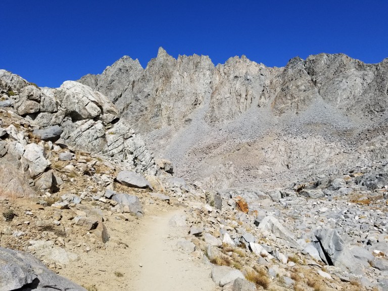
This area is truly amazing, being up there you would never know it was in such close proximity to a paved road and Trail Head. The trail winds around like a snake stacked upon itself, carved deeply into thick, dense rock. This path is nestled among the tallest of jagged, craggy peaks, and when you walk it, you are completely engulfed on all sides by rock, rock and more rock. Namely, the most prominent peaks of Mount Agassiz and Mount Winchell, both towering over 13,000 ft, so close by that you can touch them. In fact, we met a guy who had just come down from Agassiz! It all makes me feel like I am standing in a cathedral, the scale is overwhelming, he sense of reverence unavoidable, and as much as I try, it’s impossible to really take it all in, to truly grasp the immensity of it all. I take several photos and look up in awe, then quickly tuck my head back down to focus on my feet so I don’t bite the dust on the rocky, twisty path down.

We drop down 500 ft and cross paths with a woman who is climbing uphill. With beads of sweat on her face, she is clearly winded and glad to stop to let us by. She stops to talk with us as we are taking photos standing on an outcropping with yet another magnificent backdrop. She felt the need to share with us some interesting and definitely morbid information about a catastrophic rock slide that took out a herd of 30 deer just down below. She heard about it from a Ranger and saw it for herself on the hike up. We were about to witness the carnage ourselves. Apparently it had happened a few months ago, as the bodies of the deer were decomposing, dried out masses of tangled fur, bones and picked over flesh that was now dried to the consistency of jerky. She warned us, the smell was not terrible, but “smells a lot like mutton…you will see.”
We heeded her warning, not exactly sure what to expect, and pushed on down the switchbacks until we got stopped in our tracks. Yes, there was a smell, yes there was carnage, masses of it, and there were also flies…. and maggots. It was one of the most eerie things I’ve seen in my life. Why on earth would a herd of deer, 30+ of them no less, be on the side of a talus and boulder slope above 11,000 ft where there is no vegetation, no water, no nothing for them? Bizarre. Completely a freak occurrence of nature. The mangled bodies came all the way out to the trail, and a few bones were even scattered on the other side. We stood there in a mix of awe, disgust, curiousity and sadness over this mess. Still, I couldn’t help but take photos, and then suddenly, it was time to move on, I needed to not be around it anymore. I had lunch to think about…..


We pushed on for the next hour at a 3+ mph pace, something rarely experienced or even possible on the SHR, and we pushed it because were hungry, thirsty and hot. We still hadn’t found much in the way of shade. We needed it, and we needed water and a flat place to sit and take a break. We needed to take the sweaty shoes off and stuff our faces with whatever leftover snacks we could muster from our nearly empty food supply. I made a couple “sandwiches” with the tortillas I still had, some cheese, hot sauce and crumbs of my BBQ potato chips. We chowed those down, and sucked down fresh cold water, which tasted so amazing. In 30 minutes we were rejuvenated and ready to crank out the remaining 3.3 miles to the trail head at South Lake. We had flipped the switch in our brains that allows you to start thinking about town food and a hot shower and a real bed. Things that are really not missed until you know they are so near.
Town Day, whoop!!!


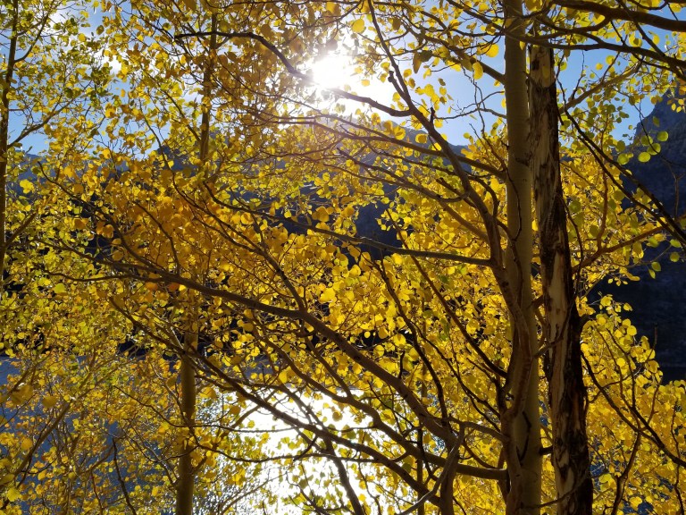
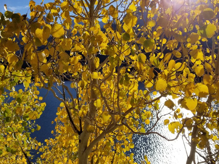
We floated down the trail at a good cruising speed, when I suddenly realized I was having some remorse, for I was not getting back on trail tomorrow. I have to take a week off for a work obligation and I have to fly to Boston for it. I will be doing a total 180 with my focus shifting from this life to that life, almost instantaneously. So, I started to slow down, started to gaze at the trees, started to imagine my body like a sponge absorbing the energy of the forest, the aspens turning too a brilliant yellow, quivering in the wind and glittering with sunlight, and I started to make amends with the fact that I was temporarily saying goodbye.
The last little stretch of trail, for about a half mile or so, follows along a straight line on a ridge overlooking South Lake. To the West, down slope, and to the side of the trail, there is a line of aspen trees that were glowing and screaming “fall is here!” I stopped to listen and look, and feel. They were stunning, they were perfect. If only I could stand there forever, watching and listening to that magic, if only the sun would stay right there and sparkle through the movement of their leaves, catching my eye in little glimmers that are so blindingly bright. How do I make this moment last forever?
And that’s just it. The moment, becomes a memory so quickly, because you must move on, you must keep walking. But you can save it to your hard drive, and you can access it anytime you want for the rest of your life. What a gift. I have so many of these memories, I have said “goodbye” to the trail, to magical places in the wilderness, time and time again, and always, I leave with a kiss on the cheek, saying
“thank you” ….. “I will be back.”

I stopped try to tell people about experiences in my life, because I found it frustrating not to be able to adequately describe them. Yet, you seem to do it so effortlessly. Thank you for sharing.
Glad you got something out of my sharing 🙂
Thank you Milissa for you and Cornelius taking this old man on a wonderful journey to places I will never ever get to see in person. After 30 years I will be hiking near me which happens to be the Goat Rocks this coming spring and summer.